2008 Annual Site Environmental Report Available:
Click Here
Heavy Rainstorms Have Minimal Impact At WVDP
The Ashford area which includes the West Valley Demonstration Project Site incurred heavy rainfall August 9-10, 2009. Several inches of rain fell during two rainfall events on August 9 and 10, which were preceded by a 1.81 inch rainfall on August 5. The 200-acre WVDP site experienced high water levels and power outages during and immediately following the storm. Neighboring areas experienced high water levels, power outages, and erosion. There were no unplanned or unauthorized releases of radiological contaminants associated with the WVDP site during or after the storm.
Site Reservoirs located on the
WNY Nuclear Service Center |
|
Two reservoirs that supply clean water for the site experienced high water levels during and immediately following the storm event. The reservoirs and dams are located southeast of the 200-acre Project premises and are not located in close proximity to any waste storage or disposal areas or any facilities that house radioactive materials. Due to the site-wide power outage, adjustments to dam outlet controls were made manually between ~6:00 a.m. on August 10 and 6:00 a.m. on August 11 to increase outflow.
Inspections following the storm identified erosion to the reservoirs’ dams and spillway. An independent engineering firm with dam expertise was contracted to evaluate the extent of the erosion and determined the dams and spillway remain structurally sound. Erosion repairs are planned. In the interim, the WVDP has enhanced the inspection frequency until repairs are completed (inspect dams weekly and after rain
events >1 inch of rain in 24 hours). The Lake 2 Reservoir and pump house are pictured above. The lake is located approximately ½ mile upstream of the WVDP Project Premises. |
B & P Railroad Repair Project
|
|
Ongoing work to repair a past landslide area off-site south of the Western New York Nuclear Service Center wasimpacted by flooding from pond near Fox Valley Road. The damage included washout of recently placed fill and erosion along Buttermilk Creek at the base of the railroad. A post-storm engineering
review of the repair area was performed on August
18. Results of that review indicate that the landslide repairs conducted prior to the storm likely prevented a more serious failure of the hillside east of Fox Valley Road. |
Flood Damage Repaired
|
|
August 26, flooding damage has been repaired and work on the landslide area has resumed. |
Environmental Monitoring
|
|
A background surface water monitoring station upstream of the site on Buttermilk Creek was damaged and was put back in service the following day using battery power. Plans are underway to replace the monitoring station. The station is pictured before the storm at left. All other monitoring systems remained operational, except for down time during the loss of utility power.
The site wide power outages caused the WVDP’s meteorological tower and rain gauge to go off-line, therefore the rainfall total for the August 9-10 storms is incomplete. Weather stations at nearby monitoring sites (West Valley and Springville Griffith-
Institute schools) also went off-line due to power outages. As a result of the power outages and
exhaustion of battery backup power for the WVDP Meteorological Tower, rainfall amounts were
not recorded from 4:30 p.m. on August 9 through 7:15 a.m. August 10. The recorded rainfall amounts from the WVDP meteorological tower were 1.09 inches (August 9) and .92 inches (August 10). |
Progress At The NDA
The NDA cap project nears completion.
|
|
|
NOTICE - Public Comment Period on WV DEIS Closed |
| |
The public comment period for the "Revised Draft Environmental Impact Statement (EIS) for Decommissioning and/or Long-Term Stewardship at the West Valley Demonstration Project & Western NY Nuclear Service Center [DOE/EIS-0226D (Revised)]" has now closed. Comments are being considered and responses will be included in the Final EIS.
|
|
Quarterly Public Meeting Change |

|
Quarterly Public Meetings are held for the WVDP.....
|
|
Waste Management |
|
Remotely processing a waste box
full of jumpers can take more than a week’s time. Pictured to the left is.....
|
|
NRC License Disposal Area |
|
Currently, work at the NDA involves the installation of a slurry wall to reduce.....
|
|
High Hazard Projects |
|
Mechanical isolations and set up for the
application of a layer of grout on the floor of the..... |
|
Community Support |
|
We will soon be posting info on the Community Support that we receive.....
|
|
Draft EIS
Click here to view the Revised Draft Environmental Impact Statement For Decommissioning and/or
Long-Term Stewardship at the West Valley Demonstration Project & Western NY Nuclear Service
Center [DOE/EIS-0226D (Revised)]
Rev. 1 - Phase 1 Decommissioning plan Click Here
Progress Report
Here is the latest Progress Report.
EM Project Baseline
Click here to view the Project Baseline for the WVDP and other small sites.
Where We Are
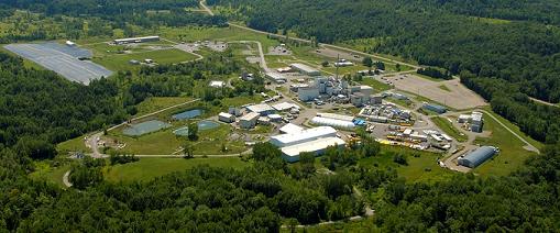
The West Valley Demonstration Project is located approimately 35 miles South of Buffalo, in Cattaraugus County, at West Valley, New York. Click here for a map.
|